coolhikinggear.com

  • Men’s
    • Best Hiking Rain Jackets for Men In 2024
    • Best Men’s Hardshell Jackets Of 2023
    • Best Hiking Pants For Men In 2023
    • Best Ultralight Rain Pants For Men
    • Best Men’s Daypacks For Hiking In 2023
    • Best Backpacking Backpacks For Men In 2023
    • Best Base Layers For Men In 2023
  • Women’s
    • The Best Hiking Rain Jackets For Women In 2023
    • Best Women’s Hardshell Jackets Of 2023
    • Best Hiking Pants For Women In 2023
    • Best Ultralight Rain Pants For Women
    • Best Daypacks For Women
    • Best Backpacking Backpacks For Women In 2023
    • Best Base Layers For Women In 2023
  • Hiking Accessories
    • Best Hiking Poles
    • Best Trekking Pole Monopod Camera Mount
    • Best Hiking Headlamps
    • The Best Hiking Watches In 2023
    • The Best Hiking Gloves In 2023
    • Best Hydration Bladders For Hiking In 2023
    • Best Compass For Hiking Our Top Picks
    • Cool Hiking Gadgets
  • Footwear
    • The Best Men’s Hiking Boots In 2024!
    • Best Hiking Shoes For Men In 2023
    • The Best Women’s Hiking Boots In 2023!
    • Best Hiking Shoes For Women In 2023
    • Best Hiking Sandals
    • Best Hiking Sandals For Women in 2023
  • Hiking Guides and Resources

Best Sleeping Bag For Hiking The Appalachian Trail

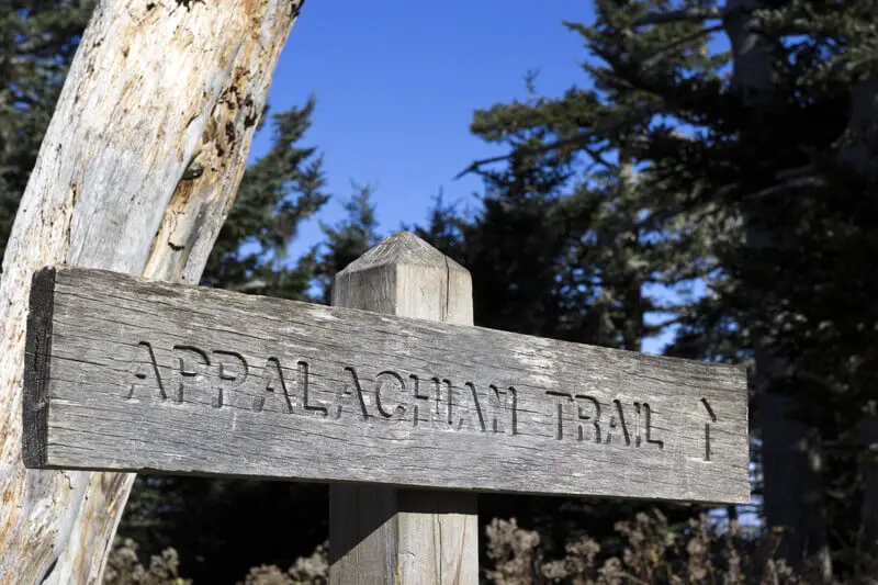
Hiking the Appalachian Trail is the experience of a lifetime for those lucky enough to have the opportunity and the time to complete one of the nation’s most popular thru-hikes.

But how do you set yourself up for success with such a physically and mentally challenging experience? Finding the best sleeping bag for hiking the Appalachian Trail, is one of the more important aspects to help ensure your success.

The importance of a good night’s sleep on a such a long thru-hike cannot be overstated for both your physical and mental recuperation.

Hiking the AT

The Appalachian Trail is one of the most famous long-distance hiking trails. Passing through 14 states over approximately 2,185 miles between Georgia and Maine.

The average thru-hiker takes around 165 days to complete the Appalachian Trail from start to end, on average anywhere between five to seven months.

As you can imagine, over this huge distance, weather conditions and terrain vary enormously. The vast majority of hikers attempt the Appalachian Trail northbound in springtime and aim to finish before winter hits in Maine, potentially closing the Mount Katahdin finish point.

Leave early and you’ll be faced with low starting temperatures or leave later and risk missing the finish due to winter weather. Late March through early April is the optimal period for departure, although this is peak season on the trail.

If that bothers you, you may want to try to depart earlier or later depending upon your hiking style, level of fitness and weather conditions.

What to Expect

The AT varies in elevation from 124 feet at its lowest point in Bear Mountain State Park, New York, up to 6,643 feet at Clingmans Dome in the Great Smoky Mountains National Park and you can expect subfreezing temperatures.

Daypack On The Trail

Completing the AT in the recommended spring, summer and early fall window, should, however, rule out some of the more harsh weather conditions.

In spite of its length and reputation, the AT is not a wilderness trail, with the exception of the 100-mile Wilderness Section, you will cross a lot of roads and are able to stop at local towns usually just a short distance away.

These nearby towns are essential for food stops but also enable you to simply take a day’s break, pick up mail, replace any broken or unsuitable equipment and to mail unwanted stuff home.

Although it is recommended you take a suitable tent, there are also around 260 shelters spaced along the trail. Available on a first come, first served basis, you cannot rely on shelters alone.

Your choice of sleeping bag for the AT should take all of these points into account. If you do not already have a suitable sleeping bag, or are thinking of upgrading here’s a breakdown of some of the essential qualities you need to look for in a sleeping bag for hiking the Appalachian Trail.

Choosing the Right Sleeping Bag for Hiking the AT

The main choices you’ll need to make when choosing your sleeping bag for the Appalachian Trail thru-hike, are what type of material and how warm.

Before you decide, it may be best to consider whether or not you wish to change your sleeping bag for summer, by mailing one home and having a lighter one sent out. Or you could also consider using a substantial liner to increase warmth and using it alone at the height of summer.

Down or Synthetic?

In general, down sleeping bags are preferable to synthetic bags for several reasons, there are, however, circumstances where synthetic bags can prove preferable. Down bags are lighter, keep you warmer and are more compressible, meaning they take up less space in your pack.

On the other hand, down bags are more expensive than their synthetic counterparts and are not suitable if you’re planning on sleeping in environments which may be damp, such as a tent without a ground sheet.

Wet down bags can lead to hypothermia as all heat produced is absorbed by the damp down, unlike quicker drying synthetic. There is, however, a range of damp-resistant down sleeping bags.

In these bags, the down is treated with a hydrophobic coating, meaning it repels water on a molecular level rather than absorbing it. Naturally, this comes at a price.

Whether an adventure of a lifetime, such as an AT thru-hike, merits the extra cost is a personal decision. Sleeping well and waking feeling refreshed is extremely important to completing a long thru-hike.

Temperature Rating

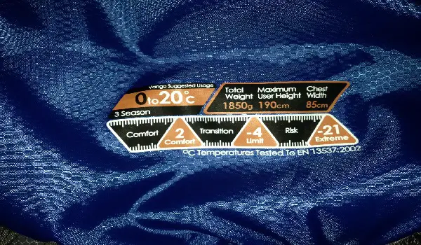
A spring to early fall thru-hike on the AT encompasses a wide range of temperatures. If you’re just planning on sticking with the one bag throughout your hike then a 20 degree F (about minus 6 C) rating is probably going to be your best bet.

The rating will be listed on the outside of the sleeping bag and also on the bag itself. It’s easy to follow and pretty much self explanatory, see the example below.

Sleeping Bag Label

If you tend to feel the cold, go for a warmer one. In either case, if you can, taking a liner will add a little warmth and if the summer does get pretty hot, you can always use the liner alone for the hottest nights.

If you’re planning on mailing home your winter sleeping bag and getting a lighter one sent, then you can choose two bags with a greater temperature difference. Just remember, depending on your altitude, it can still get pretty cold even in summer.

In general, it is important to ensure that you will be warm enough and feel comfortable enough to sleep well and to complete your thru-hike. Try out your sleeping bag before leaving, sleeping well is essential to maintaining the positive mental energy needed to succeed.

Weight

Ideally the lighter the better, but do not sacrifice comfort and warmth for weight alone or you’ll soon be struggling to carry your lightweight pack due to lack of sleep.

Around 3 pounds is a decent weight to aim for, although ultralighters will probably aim more around the 2 pound mark.

Shape and Style

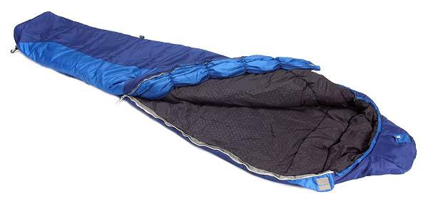
There are lots of different styles of sleeping bags. For the AT you’re going to be best looking at maximum heat retention and mummy-style bags with their built-in hoods are possibly the best option.

Snugpak Chrysalis 3 Sleeping Bag

However, you need to be comfortable and choose what works for you depending upon your sleeping style. Some people move around a lot in their sleep and prefer roomier bags, others less so.

There are advantages to using hiking sleeping quilts and some people use them on thru-hikes.

If you don’t want to go with a traditional mummy-style choice then try out several different designs, but remember if you opt for a quilt style you may have to bring along extra layers and headwear to increase heat retention.

If possible try sleeping in a few different types of bag before committing to a purchase.

Price

It’s definitely worth spending a maximum on quality. Not everyone has the option of spending half a year on the trail and for most it is the opportunity of a lifetime.

A good sleeping bag will last and will serve you well for future trips, so it really is worth making the investment. When the going gets tough you’ll be glad you spent the extra.

As with anything you can spend a lot, or a little, or somewhere inbetween. As always, the general rule is that, broadly speaking, the more you spend on a bag from a good outdoor brand name, the better quality bag you are going to get.

Recommendations

We like the Western Mountaineering UltraLite 20 Degree Sleeping Bag. A 20 degree down sleeping bag for colder temperatures.

Check out the Western Mountaineering Ultralite 20 Degree Sleeping Bag on Amazon

This ultralight, highly compressible, down sleeping bag from Western Mountaineering is a top pick with thru-hikers. Special features include a heat retention collar and a special coating to keep the down filling dry, whatever conditions you may find yourself in. Find out more on Amazon

For warmer temperatures, we recommend the Marmot Never Winter Sleeping Bag.

Check out the Marmot Never Winter Sleeping Bag on Amazon

Marmot have created the Never Winter summer, down sleeping bag to ensure that you stay warm even on those unexpected colder summer nights.

Highly compressible and lightweight, this bag also has a fold down second zipper for added ventilation, while the treated down ensures maximum water resistance. Check out all of this bag’s extra features here.

Additional Resources

Check out the official national park website as an excellent starting point for researching your At trip!

Conclusion

The best sleeping bag for hiking the Appalachian Trail depends upon a lot of factors. However, where possible look for warmth, light weight and packbility.

Whether you change part way or stick with the same one will influence your temperature rating, as will how warm you like to sleep. If you’re unsure try several models, this is the hike of a lifetime so make sure you’re as prepared as possible to succeed!

The Yearling Trail in Ocala National Forest, Florida

Continuing on with my explorations in Florida, last week I had the pleasure to hike on a really nice trail in Ocala National Forest. The trail is called ‘The Yearling Trail’.

The Yearling Trail

It’s located in a place known as ‘Pat’s Island’. The trail head is located across from the main entrance to Silver Glen Springs Recreation Park, so it is pretty easy to find.

A friend of mine recommended it to me. He also informed me about the history of the area there and that it, and it’s former inhabitants, led to a classic book, a Pulitzer Prize winning book no less, which was eventually made into a movie.

The book was called ‘The Yearling’ and was written by Marjorie Kinnan Rawlings. It is considered one of the great works of American literature. My friend had read it before he moved down to the Ocala area, and he actually said the novel influenced him when he was deciding to make the move to the Ocala area.

I haven’t read it myself but after having hiked the trail, I am definitely keen to read it. I of course would like to see the movie too which is also based, on the actual history of the area, some more on that next.

Some History

The brief factual history is that in and around the 1870’s, a former confederate soldier and his wife, Reuben and Sara Jane Long, moved to the area as pioneer farmers.

They set up a homestead there and worked the land growing peas, corn, beans, etc. Their son Melvin found and adopted a fawn and named it ‘Flag’.

Half a century later, Rawlings spent time at the Long homestead and she learnt of the story about the fawn. This ultimately was the inspiration which lead to her writing the book.

What’s so neat about the trail, is that parts of the Homestead and remnants of the Long family having lived there are dotted throughout the trail. The one I found the most intriguing is the Long Cemetery where Reuben and Sarah Jane are buried as well as other family members.

Intrigued!

There is something very intriguing as you look at the tombstones and crosses marking the graves, it sparks a sense of wonder at what life must have been like for them back in the day.

I noticed that many of the family buried there died quite young, and it was fascinating to see some of the causes of death that were marked on the graves.

If I recall correctly, one grave indicated a young man who died from a hunting accident while another indicated a younger girl who died from her dress catching fire.

In fact, most of the people buried there had quite short life spans, so it was clear that life was very tough in those days. There were only two people I think who lived to ripe old ages, one who seemed to live into their 70’s and one into their 80’s. Living to that age in those days  I assumewas the exception and not the rule of course.

Anyway, as I stood in the graveyard, I really did feel a sense of wonder as I mentioned. Like I almost could see and hear the family going about their daily life.

The daily fight for survival on Pat’s Island in the Florida heat must have been tough, but they no doubt had their moments of joy, happiness and celebration of life there too. Perhaps for Reuben it was almost a respite after having lived through the horror of war.

The Hike

The trail head is really well marked and can be accessed from SR 19, more directions here. Note, be careful with the trail map listed on that link to the official government website as I think the number markings, for areas of interest which are signposted along the trail, are slightly off.

I used the map from that and it didn’t seem to fully match what was on the ground. I noticed this as when I was trying to find the graveyard, the map on the website didn’t seem to match up to what was on the ground.

However, as you walk a bit into the trail itself, there is a big map board on the left hand side, pictured below, which you can’t miss, and it is accurate relative to the ground.

The Yearling Trail Head Map Board

The trail has two loops, the outer loop is about 5.5 miles and the inner loop is about 3.5 miles. I recommend the longer hike. The trail takes in beautiful forest and sandy loops with areas of peaceful forest canopy which is a treat to hike through.

Wildlife and Points of Interest

There is also plenty of local wildlife around on the trail, I saw some beautiful butterflies and I even had a snake slither out across my path as I hiked along the trail.

I also walked into a spiders web as I turned a tight corner on the trail and my attention had me looking backwards. I don’t think it was a banana spider, but it was big enough and thankfully went the other direction to my head lol :-). I don’t think a nip from a snake or a spider would be welcomed, so try and avoid that I think!

Also, as you hike around the trail you will come to various points of interest. You can follow the markers sequentially from 1, or you can the trail in reverse, whatever you prefer. If you follow sequentially, you will veer left of the trail to follow the loops, if you go in reverse order, you will continue straight.

Some of the main items on the trail are located at markers on the trail. Marker 8 is in front of the former Long Homestead, a cistern used to catch rain water is all that remains. Marker 9 is where you can veer off the trail to see the Long Cemetery, definitely worth taking a look at.

Marker 10 is noted as the site of Calvin Long’s homestead which was where Marjorie learned about the fawn.

It’s worth noting as well that when the movie was made, with Gregory Peck playing Ezra ‘Penny’ Baxter, they filmed a lot of the scenes in the actual area. The video I took below will give you a feel for the hike itself and also shows some of the main points of interest along the trail.

Things to Think About

It’s an easy trail, flat with a clear path with easy to follow markers the whole way along. The only things I would mention are firstly to be careful of the sun, as it can be really hot. Ensure you have a good amount of water with you, and if you can keep the water cool, all the better!

The other thing to watch for is sand spurs. They really are a pain and if you’re not familiar with them, you can see them in the video below, they can give you a nasty thorny nip if you get one caught between your socks and your skin.

They hang off the grass and attach to your boots. I recommend to not let them build up on your boots, so to stop every so often to remove them. Be careful how you grab them though, as they will easily pierce your skin if you grab them too firmly.

Luckily, they only seemed to be present in sections of the trail, not for the whole hike. Hiking boots are a really good idea, light ones as it is usually quite hot there, but you can do the hike in sneakers no problem.

I actually forgot to put my hiking boots in the car when I set out, so I didn’t have them with me when I go to the trail head, d’oh!

Watch out for the Sand Spurs!

I met a gentleman and his wife in the car park, just before I started out in the trail, who had just finished the hike and they told me to be wary of the sand spurs as they sat picking them off their hiking boots, which were covered with them!

As I only had my tennis shoes, I was a little concerned but I just watched my steps when going through the grass that had the spurs and, as mentioned above, took time to remove them as I went, so it worked out fine.

Conclusion

If you’re in the Ocala area, a trip to the Yearling trail in Ocala National Forest, is definitely worth it. There are oodles more trails to check out, springs to swim in and so on so you could easily spend a few days exploring the area.

As in most of Florida, the land is pretty flat, so you aren’t hiking mountains as such. However, given the heat most of the year round, it’s probably not necessarily a bad thing that you don’t have to haul up any hills.

As with Leon Sinks Geological Area, The Yearling Trail has a lot of natural beauty and character, and these trails are a lot of fun to explore. I definitely recommend The Yearling Trail!

A Hot and Humid Hike in Leon Sinks Geological Area, Florida!

A few days ago I was in Tallahassee, the State capital of Florida. I was there visiting a friend of mine for a couple of days while travelling through Florida. He knows I love to hike, so he suggested that when I got there we could head out to Leon Sinks Geological Area for a hike on some of the trails there.

Leon Sinks Geological Area

Now, Florida is generally pretty flat, so there isn’t much in terms of hills there or in most parts of the State. However, the park has lots of really beautiful forest which is a joy to hike in.

So, we planned to head there and take in about 5 to 6 miles of the trails along with his beautiful new Vizsla dog, Rose. So, after I arrived at his place and we caught up, we started to head out to Leon Sinks.

Some Background

Now, a brief word on Leon Sinks Geological area might be useful to provide some background. Florida sits on a ridge of limestone. Limestone of course wears away in time with water, which leads to the holes developing in the rock.

This is known as aquifer, or permeable rock, and over time, sink holes appear as smaller holes merge through the process of erosion in the rock.

Not good if you have built your house on top of one! However, they can be very useful if there is a water source below the rock as it means the water can come up through the sink hole. As far as I understand it, these sinkholes are how Florida gets its water supply.

I stress again, that I am no geological expert but hopefully this gives a little bit of background context. The Leon Sinks Geological area has a bunch of these sinkholes located in and around the trails, the largest being one called ‘Big Dismal’ … what a great name 🙂

Hot and Humid!

Anyway, it’s lucky that there is a source of water coming up from the ground as Florida tends to be pretty hot a lot of the year round, so having an abundance of water coming from the earth, can only be a good thing for the State I think.

So, when my friend and I went to Leon Sinks, it was 91 degrees fahrenheit (33 C) so pretty hot!

Also, it was very humid, so sticky. We set out to cover all of the trails, and as we hiked, my friend, who happens to have studied and worked as an environmental / ecological scientist, told me about all the different trees and plants in the forest which was very interesting.

It was a beautiful hike but man oh man, was it hot! Now, we had packed a lot of water for ourselves and for Rose, and we stopped on several occasions to drink.

My friend is a native Floridian so I figured he’d be used to hiking in this kind of heat, but just like me, he was sweating a hell of a lot as we hiked along the trails.

Watch the Sun and Stay Hydrated

I have written before about how you need to respect the sun when you’re out on the trail. It really can be lethal if you’re not careful, especially if you are hiking in really hot areas, like a desert. Last year I hiked in Death Valley, but this was more intense.

Probably because the time of year in Death Valley when I was there was Spring, so not the hottest time of year, but also possible because of the humidity in Florida, it was pretty punishing!

It occurred to me that my normal preferred way of carrying drinking water while hiking, may not be best suited to this type of heat. Even if I put a lot of ice into my hydration bladder, I’m really not sure how long it would stop it from getting too hot.

A bladder insulator / cover, to keep it cool, would most likely be needed. My friend had a chill bag with him so that did the trick for us on the day so we had cold water for the whole hike.

Conclusion

This was just a short post today about being careful if you plan to hike in very hot weather. I am typically more accustomed to hiking in cold and wet weather and so I am well prepared for those conditions.

The heat from a sun beating down provides its very own set of problems which you need to be very mindful of, especially if you’re not used to hiking in that kind of weather.

Be sure to pack plenty of water and if you can, have some method to keep it as cool as possible, utilizing ice, bladder cover, chill packs, or whatever works to do the job.

Finally, if you happen to be in Tallahassee in Florida, a hike in the Leon Sinks Geological area is not too far outside of town and it is really worth a visit. There are 3 trails with about 6 miles of trails but it is a fine way to spend a couple of hours as the forest he trails are in, is just beautiful.

Zion National Park, A Picture Gallery

Last year I had the pleasure of travelling to the West Coast of the US to visit some of the truly beautiful and amazing national parks that are on offer there.

It is truly a hikers paradise and while I visited four of the main national parks while I was there, I still of course only scratched the surface of what is on offer.

While I truly loved the four parks I visited (Sequoia, Death Valley, Zion and The Grand Canyon), I have to say that Zion was my favorite. The scenic beauty and the copper and autumnal hues of the sandstone, mountains and canyons against a crisp blue sky setting, was truly stunning.

In this article I thought I’d compile some Zion National Park pictures into a picture gallery to try and give you a feel for what you can look forward to if you are thinking of heading to Zion for some hiking, or just to get away and relax for a bit.

1. Zion National Park

Zion National Park

The park is found in Utah in the US, near the town of Springdale, although Springdale is not the only entrance to the park. It is about 229 square miles in size and is predominantly made formed from sandstone, limestone, gypsum and conglomerate.

It was first established in 1919 and is a very popular location for hikers and tourists, with visitor numbers on the increase year on year in recent times.

2. The Virgin River

Virgin Narrows River in Zion National Park

The Virgin River is one of the main attractions in Zion. It is actually a tributary of the Colorado River that runs through Utah, Nevada and Arizona. It is approximately 162 miles long and is named after Thomas Virgin, believed to be the first American to see it while exploring the area.

3. Zion Canyon

Zion Canyon Overlook

Another Big draw in Zion National Park is of course Zion Canyon. Cut through Navajo Sandstone, it is the main feature within the park and runs 15 miles long and up to half a mile wide. It’s a truly beautiful site to behold

4. Angels Landing

People On The Ridge On Angels Landing

Angels Landing was my main hike when I travelled to Zion. It’s one of the better known and more famous hikes in the park and people travel there specifically to do it. Anywhere from three to five hours should you see you around comfortably, depending on how fast you hike of course.

Be careful if you suffer from Vertigo or if heights make you queasy, there are some significant drops and I believe, at least I was told this, that people die falling from it every year.

Mainly from not being careful as opposed to anything else. Take your time, wear appropriate hiking boots or shoes with good grip, go at a steady pace for your party, and you should be fine. As always, bring water and some snacks.

5. The Narrows

When people go to visit Zion Canyon, typically top of their list, is to hike the Narrows. The Narrows trail is basically following the Virgin River through slot canyons.

Zion Narrows 1

There are different levels of hike you can do, from a shorter 3 to 4 hour hike known as Wall Street, see further below, to the whole hike from Chamberlain Ranch down to the Temple of Sinawava.

If you don’t like water, parts of the Narrows may not be your thing as you can be waist deep in places. Next time I go back, hiking the whole Narrows is top of my list!

Zion Hiker

The hike can be anything up to 16 miles, if you decided to do the whole thing. If you want to hike the Narrows, be sure to go at an appropriate time of year as in late Autumn, Winter and early Spring, the water levels can be too high due to run off so hiking the Narrows is not permitted.

Also, be aware that there is a risk of flash floods all year round e.g. from thunder storms.

6. Wall Street

Zion Narrows Wall Street

No, we’re not getting all financial all of a sudden 🙂 Wall Street is probably the most popular and frequented hike of the Narrows. This is mainly as it the most accessible, suitable for most ages and can be completed in 3 to 4 hours.

It’s known as the best slot canyon in America and in it the walls squeeze down to a tidy 20 feet wide, into a mile-long corridor at the mouth of the Orderville Canyon … AKA Wall Street.

7. Some Autumnal Hues

Zion Autumn

As referenced above, the copper and Autumnal hues that are a standard part of Zion, are what really set’s the park alive in terms of its scenic beauty.

The red hued sandstone rock against a blue sky is complimented further by the beautiful ecology and wildlife that is on offer. It all goes to compliment the beauty and majesty of Zion National Park.

8. Temple of Sinawava

Pulpit at the Temple of Sinawava

The Temple of Sinawava, is a vertical-walled natural amphitheater that runs nearly 3,000 feet (910 m) deep. Many take this to be the start of Zion Canyon but the canyon actually begins much further ahead where the river splits.

It is one of the most frequented stops on the park shuttle bus as it’s the end of the Narrows hike. Pictured above is what is known as the pulpit, a free standing sandstone in the middle of the Temple of Sinawava.

9. Weeping Rock

Weeping Rock Zion National Park

Weeping Rock is a fascinating sight in Zion. It’s overhanging blind arch and it “rains” every day of the year.

The spring water seeps out of the rock 100 feet above and takes nearly 1000 years to travel through the porous Navajo sandstone. Another really unique and beautiful part of the park that is worth a visit to hike around in.

10. Kolob Canyons

Kolob Canyons

The Kolob canyons part of Zion National park is to be found in the North West of the park. Here you can find plenty more hiking paradise with 2,000 foot cliff walls and plenty of winding trails to explore.

The best starting point is the Kolob canyons Visitor Center. As with other parts of Zion National Park, specific permits are required depending on the activity or trail you wish to do.

Always check with the park service folks in advance, they’re very friendly and helpful and will be only too happy to guide you on what you need to do.

11. Springdale

Springdale Beside Zion

Springdale is one of several available starting points for your trip into Zion National Park. It’s quite a sweet little town with a very chilled out vibe.

There are lots of nice eateries and stores to get replenished in after your day in the park. About 12 km’s squared in size, it sits at an elevation of 1188 meters and has a small population of about 5 to 6 hundred.

Of course it is always much busier than this as it is the Southern Gateway into Zion. The town is very well set up with plenty of parking lots which are close to a shuttle bus that takes you to the park entrance.

It’s a shuttle bus that takes you to the park shuttle bus if you will. It’s a beautiful little town and well worth staying in for a few days if you can.

As with many of the big national parks in the US, Zion itself is serviced by a park Shuttle Bus that picks you up and drops you off at your trail head of choice.

It is convenient and easy to use and works well. The buses are propane-powered and so quieter and much better for the environment that lots of noisy cars.

This was introduced in the late 90’s to move to a much greener approach to park access and it has been a great success.

The shuttle bus drivers also typically share knowledge and stories about the park as you travel from one location to the next, so it can be a very educational, interesting and humorous trip.

Conclusion

I started this gallery by saying that Zion National Park was my favorite hiking trip in my initial visit to the West coast of the US (although technically it’s more inland, I started by flying into L.A.), and I’ll finish by reiterating the same.

It’s a truly beautiful place and somewhere I look forward to visiting again. Next time, I will most likely spend up to a week in the area exploring more as I only got to hike Angel’s Landing as my schedule was tight and I needed to move on to the next adventure on the trip.

If you are thinking of visiting, be sure to check out the Zion National Park website in advance. It has loads of useful information to help you plan your visit.

Also be sure to check on the time of year you plan to visit. In and around 3 million people travel to Zion National Park every year, so the numbers visiting can be very high at peak times of the year.

Queues will obviously form and you may have to come back another day, so it is always best to plan ahead so you make the formalities as smooth as possible to give you more time to do what you came there to do, which is of course to explore the Majestic Beauty of Zion National Park!

I hope you found this gallery enjoyable, useful and possibly inspirational! Please share it and leave a comment if you do.

Hiking In The Grand Canyon, A Beautiful Way To End The Trip!

So, as we drew closer to the end of our trip, we had one more major national park on our list to visit. We had to go hiking in the Grand Canyon! How could we travel all the way over there and not pay a visit to that amazing wonder. For sure, it had to be on the to do list.

Grand Canyon 3

With our base being Las Vegas, it was about a four hour drive each way to get from there to the Grand Canyon National park. With the trips to Sequoia, Death Valley and Zion National Park, I had already put in a lot of miles driving over a few days so I wasn’t keen on spending another 8 hours driving to and from Las Vegas to the Grand Canyon.

As Las Vegas is so close, luckily, there are plenty of tour bus options you can take to get to see the Grand Canyon. Just do a Google search and you’ll get a load of options. From helicopter rides to day trips and longer excursions staying in Grand Canyon Village.

I did a Google search and found a company called Grand Adventures … they had a lot of good reviews. One of their options was the South Rim Express Tour, $125 per person at time of writing, which left at 6am and took in a hike of the the South Rim of the Canyon.

As the tour purposely beelined for the Canyon at that early hour, they were able to spend that little bit longer at the Canyon that most of the other tours on offer and still get you back to Vegas early enough. I liked the sound of that as it would give us more time at the Canyon itself.

An Early Start

We booked the tickets and the day after our Zion trip got up at 5am to get ready to make our way to Bally’s casino in Vegas to the pick-up point. An early start indeed after our hiking trip the previous day in Zion National Park!

As it turned out, there was only four of us on the day trip which was great from our perspective. The two of us and two other ladies who were on the trip got to have the whole mini bus to ourselves for the journey there and back. That meant we had a long seat each. Nice to have for sure having gotten up at 5am! Could stretch out a bit and have a snooze on the journey.

Our guide for the day was a Guy called Kevin. Very nice Guy who knew a lot about the Canyon itself and places on the way. He had lot’s of interesting and funny stories for us and kept us entertained and informed throughout the trip. From all the movie and music stars living in and around Lake Mead to interesting stories on sheep crossing bridges on the highway that he’s never actually seen sheep on. It was all very interesting.

He also really knew his stuff in terms of history about the Canyon and so on. Any question I asked he knew the answer to. Kevin knew some excellent spots to get good photo shots, see below. Of course, it’s the Grand Canyon, so there are numerous opportunities for getting some good photos in.

At The South Rim of the Grand Canyon

Hiking the South Rim of the Grand Canyon

When we got to Grand Canyon park, thankfully the traffic queues weren’t too bad, another benefit of the early start. After a rest break in the visitors center we made our way to start our hike.

We hiked for about 3 hours around the South Rim of the Canyon. We were totally blessed with the weather and we had a perfect day for it. Clear blue skies as far as the eye could see. It really lent itself to seeing the majesty of the Grand Canyon. Notice the mountains in the distance in the shot below, we really could see for miles!

Grand Canyon 6

The Colorado, Spanish for red, River flows through the Grand Canyon and has been shaping it, cutting through the stone over time, for years. We could only see it in the distance, you can just about see it in the center of the photo below, as we were staying at the rim of the canyon but you can hike down to it. With the sheer size of the Grand Canyon, you could easily spend weeks, months and possibly years exploring it.

Grand Canyon 8

The Grand Canyon is definitely a tourist mecca and so it has a lot of facilities within it, including a shuttle bus to help get you trail heads and so on through out the park.

There are numerous places to stay, lodging, camping and so on. It is busy all year round and of course much busier at peak times in Summer. I think, from chatting with Kevin, it can be pricey enough to stay within the park itself though and you need to book well in advance.

Taking In The View At The Grand Canyon

I was considering writing more about the short trip to the Grand Canyon but I think the photo’s really speak for themselves so why bother 🙂

Grand Canyon 4

This was the last hiking trip of our trip to the West Coast. Two more days and we’d be heading back to LA to get our flight out. It was quite a way to end it with such spectacular views and scenery. The sheer size of the Grand Canyon is amazing, let alone the endless opportunities to hike and experience the natural beauty of the area.

Conclusion

As with all the other parks I visited on this trip, I can’t really do the Grand Canyon justice with a short fly in day trip. Like Sequoia, Death Valley and Zion, you could easily spend a couple of weeks / months in the area enjoying the many hiking opportunities that are available.

In terms of preparation, as with Death Valley and Zion, bring plenty of water and snacks as well as sun protection in the form of sun screen, hat, sun glasses, appropriate hiking gear etc. check out the complete day hiking checklist in pictures for a reminder of stuff you may need to bring.

There are lot’s of easy trails to hike on so if you’re new to hiking you can enjoy lot’s of hiking in basic trail shoes or running shoes. I prefer hiking boots for all my hiking though and they would likely come in more useful if you went further afield into the less frequented areas within the Grand Canyon National Park. However, if it’s a hotter time of year, lighter trail shoes might be a better option for sure.

So, that was it. The last hike on our trip. We got back in the van and headed back for Las Vegas. It was a great day out and it was a marvelous way to finish things up, in terms of hiking, after the rest of our trip! I highly recommend a visit to go Hiking in the Grand Canyon, and ideally spend a few days if you can to get a chance to really explore the place a bit. I know I certainly will the next time I visit 🙂

I hope you enjoyed this short post, please like and share.

Angels Landing In Zion National Park, My Favorite Hike Of The Trip!

After we finished in Death Valley, we made our way to Las Vegas which was to be our base for the remainder of our trip. While you immediately associate Vegas with several obvious things, casinos and partying to name just two of them, there is actually quite a lot of nice places to go hiking in and around Las Vegas.

Now, I only discovered this from speaking with a tour guide at the Grand Canyon so it didn’t form part of our hiking plans but I thought it is worth mentioning here before getting into things further.

We of course wanted to check out Vegas itself, take a show in, hit the tables for a little bit and all that kind of stuff, but Vegas was a good spot to pick as a base for the last 6 days of our trip for a couple of reasons. First and foremost, there are several awesome national parks not too far away and secondly, you can get really good accommodation at a good price. Winner!

Las Vegas Strip

One of the main areas I was really looking forward to hiking in was Zion National Park in Utah. Roughly a two hour drive from Vegas, it’s very accessible for a day trip.

I had two hikes that I really wanted to do in Zion, Angels landing and the Narrows, two of the most famous on offer there I would say. Angels Landing in Zion National Park is a strenuous enough hike up onto a beautiful ridge that offers marvelous vistas.

The Narrows refers to hiking through a canyon which the Virgin River flows through. For much of the hike, there is no trail so you basically hike up or down the river itself. The full hike runs quite a distance, up to 16 miles I believe, but you can of course choose how much you do or don’t want to do.

Now, with the time available to us, I was going to have to make a call on which one to do as it was unlikely I’d get both in. The river water would probably be pretty cold in March to do the Narrows and there was something about Angel’s Landing that really appealed, so we decided to go with the 5 to 6 miles hike, round trip, up to Angels Landing. If we had enough time, we’d try get up to the Narrows afterwards.

Now, for some reason, Zion was one of the National Parks I was really looking forward to hiking in. From photo’s I had seen, it just looked really beautiful so I was very excited to go there. What can I say, except it didn’t disappoint!

Getting to and Around Zion National Park

As mentioned already, Zion was very accessible from Las Vegas where we were staying and I am sure it is very easy to get to from various other locations as the roads are excellent getting in there.

Town Beside Zion

When you arrive, the little town just beside the park is really pretty and has lots of nice shops, restaurants, etc. There is lots of parking available in that area. You can park up and there is a free shuttle bus that takes you up to the gates of Zion ( That sounds like a religious text lol 🙂 ) When you get there, you pay in, same rates as other parks from what I could see. 15 bucks per person and you have a week long pass to get access into the park. They also provide you with a map and information newsletter.

When you’re in the park itself, they have another shuttle that drives around numerous stops throughout the park which you can stop at and explore. These stops are the starting points for many of the hikes available in the park. This bus shuttle system is common in the National Parks and I have to say, I was very impressed with it. Made getting to where you needed to be, much easier as the parks are so big.

So, between the shuttle bus to the gates and the shuttle bus within the park, it’s very easy to get to and around Zion National Park.

First Impressions

It’s hard to get across the real beauty of Zion. The red and copper hues mix effortlessly with the blue skies providing endless panoramic vista’s any direction you look.

Zion National Park 1

I got a real sense of earthy space in Zion as well, not sure why exactly, probably the wide openness of the surrounding area. I could tell that Zion was quietly stacking up to be my favorite hiking spot of the trip so far. I was really enjoying it and I hadn’t really even started hiking in it!

When we got on the internal park shuttle to make our way to the Grotto to start our Angels Landing hike, the bus driver started to provide some history of the park which was very interesting. The park has been prone to floods and landslides in recent times some of which actually took out the main road in the park leaving some people already in the park stranded for several days.

He also pointed out, and I hope I am recalling this more or less accurately, that when the park started back in the day, it had less than one hundred visitors in its first year of operation. The Visitors Center was also a small cabin and one of the shuttle stops on the existing route.

Today, the park gets millions of visitors every year and the new Visitors Center at the gate is a series of large buildings with information, gear, gift shops, etc. I had noticed that there was a lot of advertising on the TV for the 5 parks in Utah, Zion being one of them. Whatever, they’re doing to promote the place, it certainly seems to be working!

Preparation

The weather was hot but pleasant with the sun shining. I covered myself up pretty good with light hiking pants, a tee and hiking hat as well as sun glasses. Sun screen is a must as well as the hat and glasses but you could opt for shorts if you preferred.

I recommend wearing hiking boots, just my preference, but trail shoes will also work well. There are plenty of people hiking it in jeans and running shoes as well, so you can go down that route too if you wish but I always think suitable hiking gear is the best option.

As mentioned above, you’ll get your map when you pay in and the internal park shuttle will take you to the Grotto to start the hike. The hike is well marked with signs, like the one below, so it’s easy to follow and as it’s such a popular hike, there will most likely be plenty of people on it. I would say you pretty much have zero chance of getting lost or going the wrong way.

Angels Landing Sign

As it’s hot, it’s wise to pack a bit of extra water as well as some snacks to keep you going on the way up over the steeper parts of the trail. A small day pack should do the trick nicely to carry your stuff.

Angels Landing

To do the Angels Landing hike, you jump off at the Grotto stop and follow the signs. There are amenities at the Grotto stop. This is another thing I like about the parks. For these well-known hikes, there are a lot of visitors, so of course, It’s a good idea to cater for their ‘needs’, shall we say.

This also comes in to the area of trails too. Many, especially the very popular ones, are very well marked and you are strongly encouraged to stick to the trails to protect the local environment. As with all the National parks though, wilderness permits are available in Zion.

As already mentioned, the Angels Landing trail is very well marked out. There are signs and clear paths to follow to get up to the ridge. It starts on the flat before starting to veer upward on a steeper and steeper gradient.

Path in Zion

This first part of the hike is very pleasant, a bit strenuous but nothing of any major difficulty for an average regular hiker. As with all the hike, there are lots of excellent photo opportunities as you make your way up. We had a beautiful clear day so I was very trigger happy on my iPhone lol 🙂

Colm In Zion

This first phase of the hike ends when you reach a plateau and you walk for a bit on the flat again through, what I think is, a canyon. You move inward into the rocky mountain before you again start to head back upward again on steep enough paths. You follow that up the whole way to the first top, or flat level on the ridge.

Now, this is where the hike starts to get really excellent. As you follow this first plateau along you see for the first time the metal chain attached to posts which will be your companion, which you will be grateful of, as you move further up a long on the ridge towards Angels Landing itself.

Start of Ridge Up To Angels Landing

This is certainly where the hike does start to get a bit trickier and if you have any fear of heights, you may wish to consider if continuing on is a good idea. As you go further up, there is a drop on either side most of the way to angels Landing and it can be a bit hairy in places. People do die on the hike every year apparently. Someone gave me a figure of an average of 5 people a year falling of it and dying but I don’t know if that statistic is accurate.

At the early stages of our hike, we had Asian couple in front of us. The lady was having a really difficult time getting up over the first part of the hike with the chain on it. She was very nervous and taking a very long time. It definitely didn’t bode well and I really hoped she wouldn’t continue. They found a spot and let us and a few others pass by them.

This part of the hike was just beautiful. As mentioned, you need to keep your wits about you in certain places and use the chain to support you to prevent you from falling off. Anyone can have a slip so you just need to take care. You also need to be wary of the biggest danger on the hike to Angels Landing, namely, other people.

Ridge View

As Angels Landing is of course very popular, there is a fair bit of traffic up to it. On more than one occasion, I saw people barge past other people on the chain, or they would continue upwards while other people were trying to come down in places where only one should pass at a time. The terrain was such, that at some point, one of the parties would have to let go of the chain while the other passed leaving them helpless if they slipped.

One man in particular sticks in my head, on two occasions I saw him pushing upwards while people were trying to come down. The first was more rude than anything, the second was just dangerous. This second time, people who obviously weren’t hikers and were somewhat shaky to say the least, where trying to negotiate a tricky bit on the same way down. Regardless, he just pushed upwards hogging the chain forcing them to stop and let go. Just plain stupid of him.

It’s worth taking your time and being courteous to others is always a good idea, it is just safer in places like Angels Landing. It’s OK to stop for a few minutes and let people get down past you, you’ll get there in a much more safer way and you get a few moments to stop and enjoy the views in the process.

Ridge View 1

The terrain is more or less rocky and you make your way up through the rocks at various points as well as over them. You need to use your hands a lot, so a bit of scrambling is required. I personally love scrambling but it’s too much for some, be prepared for a bit of it on the way up to Angel’s Landing.

The Summit

When you get to Angels Landing, you definitely feel like you earned it. It isn’t an easy hike and the last section over the ridge adds a challenging and exciting dynamic to it.

What awaits you, is stunning views. The weather stayed perfect for our whole time on the hike so it was just beautiful at the top. We spent about 15 minutes on the top, took some photos and sat down for a bit just to take it all in. There are a few outcrops from the top that you can walk out onto if you’re feeling adventurous but we were happy sitting back taking in the view.

View From Angels Landing

As it’s so popular, it can get busy on Angel’s Landing itself so we didn’t want to stay too long, let others get to spend a bit of time on the top.

The Way Back Down

The way back down, over the ridge, is probably a bit trickier than on the way up. It usually is, gravity being what it is. Again, be patient and don’t rush needlessly. A bad slip in the wrong place likely won’t end well so take your time. The chain is even more useful on the way down I can assure you 🙂

Chain On Ridge Up To Angels Landing

On the way back, when we got to the first plateau we had reached on the way up where we passed the Asian couple, I was happy to see the Asian lady sitting there. She had obviously decided to sit it out and let her partner, and I think they had a kid with them too, proceed. Always good to see some common sense, I just hope she got back down over that first bit OK as it is actually one of the trickier parts of the ridge part of the hike.

When we got back down, we headed over towards the Virgin river to take a closer look. It’s brown so the water must have a lot of silt in it. It is beautiful though and the brown water fits right along with the red and copper hues of the landscape against the backdrop of an almost bright Azure blue sky just perfectly.

Virgin River In Zion

The hike had taken us about 3 hours in total. When we looked at the time, we decided that we would have to leave the Narrows for another time as we needed to hit the road back to Las Vegas a bit earlier as we were getting up at 5 am the following morning to head off to the Grand Canyon, the last national park on our visit list for this trip.

So, reluctantly, we got back on the shuttle and started to make our way back to the car and grabbed a bite to eat before hitting the road. The Narrows would have to wait till another time but that’s cool … more reason to head back soon!

Conclusion

I’m going to make a big statement for me here. I visited four national parks on this trip (Sequoia, Death Valley, Zion and The Grand Canyon) and I have to say that Zion was my favorite. I of course loved all the others too but there was something very special about Zion, something I really liked about it.

I can easily see myself going back there and spending a week chilling out in the cool little places beside the park and taking in the stunning scenery on the many hikes available. I will be back for sure and I look forward to hiking the Narrows the next time as that is probably at the top of my list when I return.

The landscape and scenery is just special in Zion and there are lots of great photo opportunities along the way. I definitely made some memories that will stay with me for a life time. Angels Landing in Zion National Park has definitely hit my top ten hike list for sure, a great hike in a beautiful park!

I hope you found this article useful. If you did, please like, share and / or comment.

Hiking In Death Valley National Park, A Unique And Beautiful Place

After finishing up in the Giant Forest in Sequoia, we hit the road for Lone Pine. We had planned this as a stop off point on the way to Las Vegas as we were hoping to maybe have a look in and around the Whitney Portal area. Lone Pine is the gateway town to the Whitney Portal i.e. the route to climb Mount Whitney but as we had to stay longer in Three Rivers and use the morning of our second day to see the Giant Forest, this probably wasn’t going to be as likely.

Lone Pine

As it turned out, one of the Rangers in Sequoia told us that there was a lot of snow in the Whitney Portal, with that in mind so we probably would not have got to do too much there although I had a hike in the Alabama Hills in the back of my mind too.

It’s about a 4 to 5 hour drive from Three Rivers to Lone Pine, so leaving Three Rivers around 2 pm meant that we didn’t get into Lone Pine until about 7 pm. We checked into our hotel on arrival, a neat little spot called the Dow Villa Motel/Hotel that a friend recommended.

Movie History

It has a lot of history as back in the day, a lot of the old western movies were filmed in the Alabama Hills. So the movie stars, people like John Wayne and so on, stayed in hotels in Lone Pine, in particular the Dow Villa Hotel. that’s my understanding anyway. Modern movies still regularly use the Alabama Hills for filming in. The hotel itself has a lot of classic movie pictures of all the old actors, it’s pretty cool.

The staff are very friendly and they’ll be happy to walk you through the history of the hotel. There’s a museum further up the town in Lone Pine as well so if you’re a movie buff, for old Western movies, you would enjoy taking a look. The decor inside the hotel is also from back in the day so it is kind of fun and different, not your average hotel for sure. A good spot and a nice place to stay.

Back to Hiking!

The other idea we had on our agenda was to do some hiking in Death Valley National Park. We would be driving through it on our way from Lone Pine to Las Vegas so we planned to stop off on the way to get a hike or two in. As we’d arrived so late to Lone Pine, following our later than planned exit from Sequoia, on Wednesday 30th March, we decided we’d rest up that evening and plan our hiking in Death Valley for the following day.

That meant we’d skip the Alabama Hills and the Whitney Portal but we figured there may not be much easily accessible there anyway due to the snow. There are some excellent views of Mount Whitney from Lone Pine which we got to enjoy the following morning, Whitney looked truly beautiful and majestic from the main street in Lone Pine.

Mount Whitney

I will definitely be back to Lone Pine as I want to hike Mount Whitney but I would need to do it in Summer time when all the snow is gone. It can be done at other times of the year too of course but, as snow and so on will be involved it adds more complexity to it for sure e.g. crampons, etc.

Mosaic Canyon in Death Valley

So, before we left Lone Pine we spent time reviewing the map of Death Valley to see where might be good to check out for a bit of hiking as we passed through. Technically, I guess you could hike in many places in Death Valley that aren’t official trails but we wanted to stick to something pretty well known and well marked. I just had to do the tourist photo at the Death Valley sign 😉

Death Valley Sign

I’m not overly familiar with hiking in deserts so I wanted to take every precaution as Death Valley, being in a desert, is of course very hot. Therefore, a whole different set of challenges need to be taken into consideration, ones that I don’t work with on a regular basis.

After a review of the map, we decided to try and take in Mosaic Canyon before heading to do a bit or hiking in Badwater Basin. Mosaic Canyon is, roughly, in the middle of Death Valley, just beside one of the few habitations in the Valley, Stovepipe Wells.

Easy to Find

The start of the trail is well marked with a sign post pointing to it from the main road. You have to go off the main road for it and the off-road to get to the parking area is pretty rough. No problem in a 4X4 but not ideal in a hired Ford Focus lol 🙂 We took our time on the way up though and it was fine. We got to the parking area which was actually quite busy.

The hike itself runs anywhere from 1 mile to 4 miles round trip. We probably did about 3 miles, 1.5 in and 1.5 back out. Mosaic Canyon is really beautiful and there are plenty of excellent views to take in. There are some parts of it where you need to do a little bit of scrambling which added a nice extra dimension to it. The trail is mostly rock and sand on tough, but mostly flat, ground so it’s very easy to hike on.

Mosaic Canyon 2

I didn’t see any but I am told that Death Valley has plenty of Rattlers floating about so I would recommend a pair of hiking boots, just in case! You could comfortably hike in trail or even sports shoes though. Aside from snakes, there is a diverse range of wildlife in Death Valley. We ran into a coyote (At least I think that’s what it was) on the way to Mosaic Canyon and it wasn’t the least bit bothered by us as we drove by.

Coyote In Death Valley

It’s Hot!

The coves and nooks along the canyon are fun to explore and there are plenty of great photo opportunities. All in all a really nice hike. Now, as I mentioned, we only did about 3 miles round trip. I normally hike anywhere between 10 to 15 miles on a day hike so this was quite short. However, the heat adds a whole different dimension to it.

Mosaic Canyon 4

As mentioned, I’m not used to hiking in desert environments and the temperature was between 77 to 90 degrees Fahrenheit (25 to 32 Celsius) so it really does drain you quite quickly. Of course, you need to carry a lot of water with you and be sure to take an adequate amount.

You can see how easily you could get into trouble if you ran out of water and couldn’t make your way out of some place for whatever reason, the heat would dehydrate you fast! That’s also why I really wanted to stay on very clear trails as if something was to happen, someone would be along at some point.

Sunscreen is also essential as well as covering your body up to protect yourself from the very heavy heat. You could do shorts and a tee but I chose to cover up with light hiking pants and a tee as well as a sun hat. A sun hat of some kind is strongly recommended. It will protect your head from the searing heat which I for one was very grateful for.

So, in summary, those few miles, took a fair bit out of me. Just with the heat factor added in it was definitely tougher hiking in it but of course, still very enjoyable.

Badwater Salt Flats

After we finished up in Mosaic Canyon, we made our way to Badwater Basin to see the Badwater Salt Flats. The Badwater Salt Flats are located well below sea level but it seems the sea was never actually in the valley in the form it is in today.

However, it may well have been a seabed millions of years ago. It is also North Americas lowest point in terms of elevation. It’s hard to make it out in the photo below but I’ve highlighted it in the green box where the sign on the side of the basin says ‘Sea Level’. As you can see, it’s very high up.

Badwater Basin Sea Level Sign 1

The Green Box above is blown up below … hopefully you can read it OK:

Sea Level Sign At Badwater Basin

I was laughing thinking that while I couldn’t get one of North America’s highest points, Mount Whitney, on this trip I would at least get it’s lowest 🙂

As mentioned, Badwater Basin is covered in salt flats. I assume the name comes from the water being bad with all that salt. You can hike out across the flats if you want to. They run about 5 miles in distance across so you can get a 10 mile hike in round trip.

Badwater Basin 2

However, Badwater adds an additional and unique challenge to a hiker which is worth noting. The salt flats are of course a large flat area of ground covered in salt, see the picture below, which is of course white. White, as you probably know, reflects the sun, similar to how snow does. So when you hike out across the white salt flats, you not only have sun beating down on you from above, but also reflecting back up at you from below!

Sunglasses

If you’re spending any length of time hiking on the flats, I would think suitable sun glasses are also a must as I assume a similar problem to snow blindness could result from the reflecting UV rays hitting your eyes.

Badwater Basin 3

As mentioned, you’re also at the lowest point in North America. As you also probably know, if you go up in altitude, the temperature cools so the opposite applies here. As you’re down so low, the temperature which is really, really hot anyway, is hotter! Add that to the general desert environment and the reflecting salt flats, and you more or less have a cooker lol 🙂

To add some numbers for illustration, Death Valley itself can easily reach 122 degrees Fahrenheit (50 Celsius) plus in the Summer so you can just imagine what it is like in Badwater at the height of summer. In short, while it can get intensely hot in Death Valley alone, it can get ridiculously hot hiking in Badwater Basin.

I shudder to think! Frankly, I wouldn’t consider hiking in Death Valley in Summer as the temperatures would just be too much for me personally. I think, visiting in March was a good idea as although the temperatures were hot, they were manageable.

Colm In Badwater Basin

We hiked out into the flats for a mile or so and then headed back in … before we frazzled lol 🙂

Death Valley is most definitely worth a visit. It’s a special place with a very unique character. I recommend you check out all information on the National Park sites to ensure you’re well prepared for your trip before you go there. Planning as always, but especially for this type of hostile environment, is critical. You need your supplies and protections to prevent you or any member of your party from getting into difficulty.

Conclusion

While every hiking environment will have it’s own set of challenges, there is a very particular set of them in Death Valley. From extreme heat to flash floods, from rattle snakes to other not so friendly variations of snake and other wildlife. Be sure you do proper research in advance of any trip to Death Valley and prepare yourself appropriately.

If you want to hike in Death Valley, I recommend going there at a milder time of year (which is still really hot I hasten to add) as visiting in mid summer would be tough going and I think hiking would probably not be enjoyable for many at that time as it would just be too hot. It’s not uncommon for cars to give trouble in the burning summer heat as well, AC’s have a tendency to break. Not the most ideal place for that to happen!

Bring plenty of sun screen and cover up to protect yourself from the sun. I’d run with Light hiking pants, with UV protection, and a suitable tee or shirt. A proper sun hat is a really good idea as well as sun glasses, especially if you plan to hike in Badwater.

It’s worth noting that I only touch on two spots in this post, there are lots of other really neat places to visit and great opportunities for hiking in Death Valley National Park. For example, old abandoned ghost towns like Rhyolite and Leadfield sound awesome and there are numerous canyons and viewpoints throughout the park for you to explore. I’ll be back to hike in Death Valley again at some point in the future for sure.

If you enjoyed this post and found it useful, please like, share and / or leave a comment.

Hiking The Giant Forest In Sequoia National Park In March

I mentioned a couple of weeks back that I was heading to the West Coast of the US on vacation and part of that would involve a visit to some of the many stunning national parks available. I’m close to the end of my trip now and my hiking finished up with The Grand Canyon yesterday which was truly awesome.

The Big Trees Trail Sign

Going back to last week, my first hiking trip started after I left the beaches of Santa Barbara and headed for Sequoia and Kings Canyon National Park. The main gateway town to Sequoia National Park is Three Rivers. It’s pretty easy to access and as I was travelling there in March, I wasn’t expecting it to be overly busy, as it would be in Summer time for example.

When I started researching Sequoia before my trip I couldn’t find too much about what possibilities there are with regards to hiking in March so I thought a post with some information in it might be useful to others travelling in March in the future.

The Plan

So, to start, I traveled there last Tuesday 29th March 2016 and was planning to stay only one night. As this was my first visit to Sequoia and I needed to move on the following day, my primary hiking objective was to take in the Giant Forest and of course see some of the main featured Giant trees like The Lincoln Tree and of course General Sherman, the biggest of them all!

Yes, all very touristy I know 🙂 but that’s cool, you have to do the main points of interest first time out I feel and with the short time frame available to me, it seemed the best option to aim for. Please don’t get me wrong, the Giant Forest is Truly awesome and I don’t mean to talk it down in any way, but it is of course very popular with tourists.

How Much can you Hike in Sequoia in March?

This was the big question I wasn’t 100% sure about and truth be told, there is an element of pot luck involved. In March, there is still plenty of snow around in Sequoia and many of the roads to popular areas, The Crystal Cave for example, will quite likely be closed. In fact, it is possible that the Giant Forest will not be accessible. If that is the case, you are left with the lower lying areas of Sequoia like Buckeye Flat to get a bit of hiking in.

Of course, I assume you can always hike into the snowy areas by hiking up to them, you just probably can’t get a car through to get close and it is a very, very big national park. There may well be restrictions involved on that type of thing too but wilderness permits are available.

Snow Chains

When we arrived last Tuesday, we had to pay our park entry fee which was $30 for a car. That get’s you access for 1 week so a very good deal for the price. The Park Ranger at the gate told us that if we wanted to visit the Giant Forest we would need snow chains for our car. We didn’t have these but they are easily acquired (Bought / hired) in Three Rivers. The Ranger will give you a list of places to get them so they’re not hard to find.

There are three levels of show chain restrictions, if I recall correctly, when it comes to car / vehicle access, R1, R2 and R3. Each level is more restrictive than the last. So for example:

  • R1: Required that all cars must have snow tires or chains on their wheels
  • R2: required that all cars must be 4 wheel drive or have snow chains
  • R3: all vehicles must have snow chains

I stress that may not be exact as I can’t recall the precise detail but it’s more or less what it was. Again the park rangers will give you the full explanation as required.

Check Restriction Levels

The restriction level changes on a daily basis and can even change while you’re out and about in the park. So basically, as advised on the government national park site, you may need to have snow chains in your car even if you don’t need to use them when setting out as the weather can change very quickly.

Now, if you’re a passing through tourist like I was, you probably have a hire car. If that’s the case, most car rental companies don’t let you use snow chains on their cars so if you do need to use them, you could get into hassle with the rental company.

When we arrived on Tuesday, I went to one of the hire places and bought a set of snow chains. The deal was you buy them for $57.95 and if you brought them back you got $20 back. Otherwise, you keep them. They also showed me a quick video on how to put them on as it was totally new to me. When we arrived last Tuesday, the weather wasn’t great. Cloudy and there was rain but it was still very beautiful, see the picture below.

Sequoia In Clouds

Off to the Giant Forest – Take One

With our snow chains in the car, we started up to the Giant Forest. It’s a good 40 minute drive from the gate up to the forest area and you of course are going up to heights of 6,000 feet plus to get to the Forest. As we drove up, the rain turned to snow and we reached an area where a sign said that you had to put the snow chains on your car.

At this point, snow was lying on the ground and I wasn’t 100% sure about putting the chains on my rental car as I hadn’t checked on the snow chain policy from the rental company as yet. I’d also just drove 4 hours from Santa Barbara and it was about 3 pm.

We decided to leave it and go to the hotel and check in. I would research the snow chain policy (Which I found is a no no) with the rental car company and maybe practice putting them on, as having only watched a video I didn’t really feel like I had a clue on what to do lol 🙂

On the way down we decided to stop at Buckeye Flat and hike a little bit around there. It was nice but as it was getting more and more overcast, we couldn’t get a lot of great views. Still pleasant though. Hospital Rock, pictured below, is clearly visible from the road and you can follow a trail or two from there.

Starting from Hospital Rock at Buckeye Flat, we hiked about 3 miles in and around the trails there before heading back to the car. Going down towards the river is nice but brief, but there are other trails available. After 4 hours driving, it was good to stretch the legs a bit!

Getting to The Giant Forest – Take Two

The following morning, I opened the curtains and it was a beautiful morning! Clear blue skies all around with barely a hint of any clouds. Fresh and cool outside but a really good start to the day!

Sequoia Blue Sky

After getting some food, we headed up to the park gate again. We were hoping that it had stopped snowing and that we wouldn’t need the snow chains.

When we got to the gate, the Ranger told us that the snow chains would still be required 🙁 Bummer, I was really hoping I wouldn’t have to put them on. Anyway, the weather was beautiful so that was the main thing. We drove on up to the area we had been at the previous day where the snow chains had to be put on.

Now, I was a bit unsure what to do as the roads looked fine, no snow or ice on them. We were probably about a mile or two from the forest at this point. As it happened there was another Ranger there at the side of the road. I went over to him and asked him about the snow chains again. He said that he wouldn’t require me to have them on if heading on to the Giant Forest but that it was my choice whether or not to use them.

What a stroke of luck! It meant that we could continue on to the Giant Forest without putting the snow chains on the rental car, happy days! I wasn’t sure what exactly to expect as we continued on up to the car park at the Giant Forest Museum but the road was more or less perfect. there was snow and ice in the car park but no issue to get parked.

Hiking in The Giant Forest

If you’re a hiker and you want to check out the Giant Forest, General Sherman, etc. I recommend that you park at the Giant Forest Museum and then hike up from there through the forest.

The Giant Forest Museum

You can go to the Giant Forest trail, which is what we did first. It’s just up from the museum and only about a mile in length but it’s a nice introduction to the forest as you head up from there.

The Giant Forest

From there I recommend you follow one of the many trails that lead you to the General Sherman tree, the oldest tree in the Park and one of the oldest trees in the world. It’s about 3 miles to hike up to the Sherman tree from the Museum, probably 6 miles round trip depending on which trail you take but it’s by far the better option.

You can of course drive up the road and walk up to the Sherman Tree but we’re all about hiking here so that is of course what I recommend you do.

As mentioned we got a truly beautiful day, blue skies and with the chilly morning there was a bit of light snow and ice on the ground so crisp underfoot. The trails are all very well marked out, so you can get to the Giant Forest quite easily without a map.

Trail Sign

Map Trails

However, while you will be given a basic map when you pay into the Park, there are only a limited number of trails listed on it. More detailed trail maps are available in The Visitor Center, so definitely worth buying one of those if you’re staying around for a longer period. For the Giant Forest though, you’ll be fine following the signs.

The main feature of the Giant Forest is, of course, the giant sequoia trees. They really are a marvel to behold, really very beautiful and some of them have been around for thousands of years. They are of course ‘Giant’, see me standing beside one below to give you some perspective, and can only grow in very specific conditions which are of course just perfect for them at that height and location in the Park.

Colm Beside A Giant Sequoia Tree

The main trees are of course marked out, the McKinley, Lincoln and General Sherman are the main ones I think. The trail from the Museum to General Sherman can take you past the McKinley and Lincoln trees on your way to General Sherman. We crossed a small river on the way too and with the freshness of the forest, it really was a very pleasant hike.

General Sherman Tree

We started out at about 10:30 am from the museum and made it back to the Museum at about 1:30 pm. We stopped to take the scenery in and did go off on one or two other trails for a bit as well but overall, about 3 hours for approximately 6 miles.

Visiting in March

If you’re thinking of going hiking in the Giant Forest In Sequoia National Park in march, it’s worth checking out the status of the roads and so on before you get there. In winter, many parts of the park can be closed and this can run from the winter months right into March and well into April, as there can still be plenty of snow and ice around.

The National Park website, link below, is very detailed and covers just about everything you need to know but the weather forecast is something that can change on the day, and probably even an hourly basis.

Whether its the start of March or the end, might make a bit of difference in terms of the odds of having to use snow chains. However, in saying that, it could easily have been a heavy blast of snow last Tuesday night and we may not have been able to make it in without the snow chains, or perhaps even not at all. While we didn’t have to use them, the regulations are clear that we still needed to have them as they can be mandatory at any time.

Overall, I think we got really lucky not having to use the snow chains for our trip into the Giant Forest, especially as we had a rental car and had never used snow chains before. Definitely not beyond the realms of possibility that damage could have occurred followed by a hefty bill from the rental company!

As I mentioned, I was only there for one or two days, staying one night in Three Rivers Village, which is a really lovely little town.

Conclusion

We had two days to get in to see the Giant Forest and while day one was pretty crappy in terms of weather, we lucked out with day two.

You could easily spend a week or two, and much longer, checking out the trails and hiking opportunities available in Sequoia and Kings Canyon National Park. I plan to be back at some point but I am really glad to have got to see the Giant Forest.

It was the main objective for the couple of days as I passed through and I’m really pleased we got to see it in all it’s majestic glory, in bright blue skies and sunshine with crisp ground underfoot. Certainly one for the memory scrap book for sure!

If you’re planning on going there, as mentioned, definitely spend a bit of time reading and researching the National Park Website, they have all the information you need there. I’m far from a knowledgeable resource on the park after just one visit but if I can help you with any questions you may have, please feel free to leave a comment below and I’ll do my best to help if I can.

  • Facebook
  • Pinterest

What are you looking for?

Copyright © 2025 · Cool Hiking Gear

Cool Hiking Gear is a participant in the Amazon Services LLC Associates Program, an affiliate advertising program designed to provide a means for us to earn fees by linking to Amazon.com and affiliated sites.

  • About This Site
  • Privacy Policy
  • Affiliate Disclosure Statement
  • Contact